Growth
Through its first 50 years, Highspire was a small, rural village situated on major transportation routes with two major industries — milling and distilling — supporting and supported by surrounding farms.
The 1830 census was the first in which Highspire was seperately identified. In 1830 there were only 172 people, 160 whites and 12 free colored, in Highspire. In the 1850 census, the population of Highspire was 291 in 69 households and 67 dwelling units. That would soon change due to the influence of the major industrial operation of the Pennsylvania Steel Co. in neighboring Steelton. The steel mill attracted large numbers of workers and Highspire became home for many of those employees.
Starting in the 1860s, Highspire began a period of rapid growth that would continue into the early 20th century. Highspire’s location on major transportation routes, its quiet small town atmosphere, and the availability of building lots made it an attractive suburb in the late 19th and early 20th centuries.
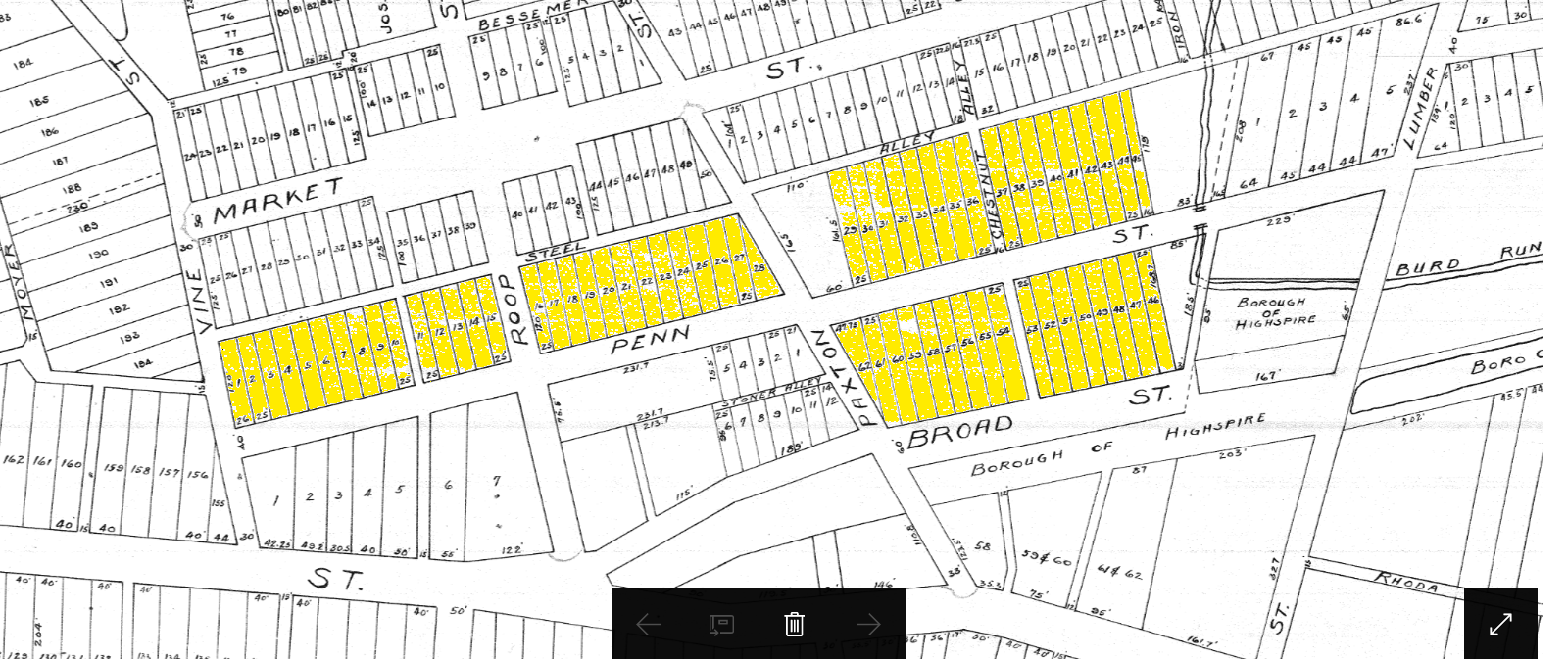
When Highspire was founded in 1814, Jacob Roop's farm occupied the land north of Second Street. Over the next 35 years he sold small parcels for building lots along Second Street between Vine and Roop Streets. In 1850 Jacob sold his 120 acre farm to his son Christian Roop for $4,000. The first planned addition of the village took place in 1858 when Christian sold nine acres and eighty seven perches of land to Harrisburg attorney David Mumma. This land was located north of Penn Street east of Vine and North of Broad Street east of Paxton. Mumma laid out 62 building lots in this parcel.
The first planned extension of Highspire by David Mumma 1858
(Lots are high lighted on early Highspire Borough plot plan.)
(Lots are high lighted on early Highspire Borough plot plan.)
The second addition was developed by Isaac Mumma in 1868. He planned 57 building lots on High and Market streets bounded by Lumber Street on the west and Wolf Street on the east. He also developed the next addition, in 1874, on the west end of Highspire adding building lots along Second Street and part of Jury Street.
In 1879, Dr. J.W. Roop, son of Christian Roop, developed 50 building lots on Market Street between Vine and Paxton streets. In 1889, Emma R. Schriver submitted a plan for 106 building lots in the southwest corner of town bounded by Jury Street on the north and the Pennsylvania Canal on the south, including Charles Street. This area was known as Schrivers’ Town, and Chalk Knob for the white door knobs. But the name that persisted to this day among long time residents is Cow Town, named for the cows that lapped up paint when houses were being built in the area.
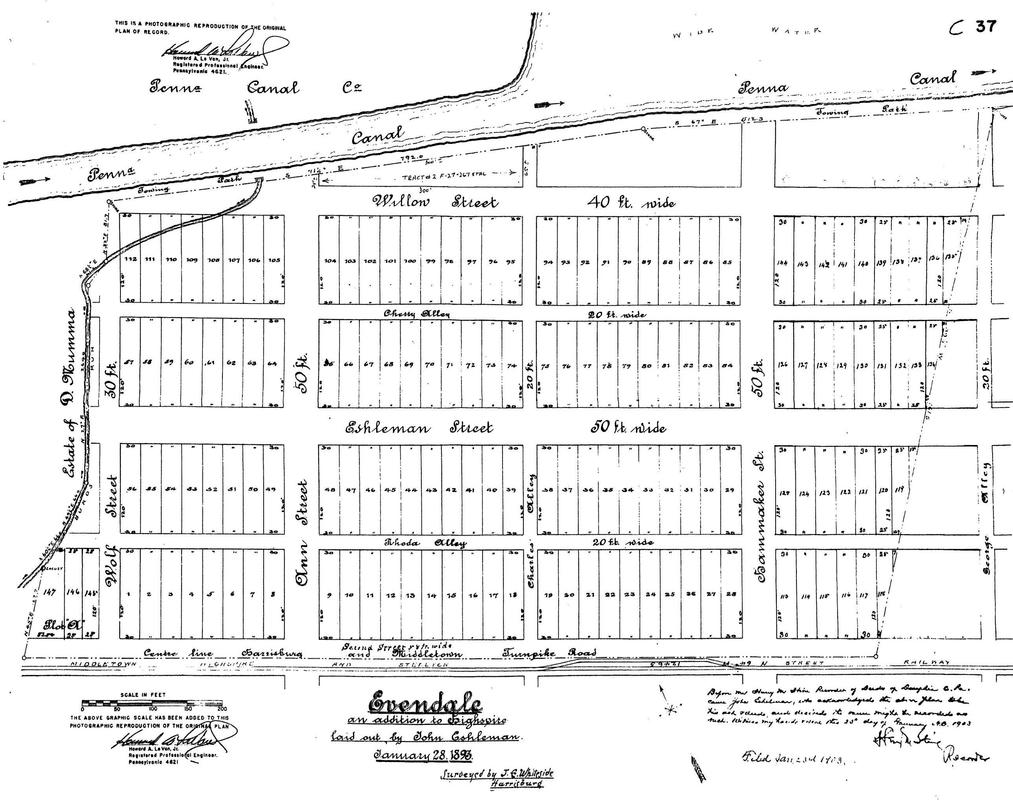
Later that same year, George W. Cumbler submitted his first plan to extend Highspire to the east with 72 building lots on the south side of Second Street, bounded by Ann Street on the west and George Avenue on the east and Elizabeth Street on the south. In 1893, John Eshleman laid out Evendale, a development of 147 building lots just east of Burd Run, bounded by Second Street to the south, Willow Street to the north, and Wolf Street to the west. It extended to the east just beyond Hammaker Street. In 1894, Jacob Klugh developed Klughton, which extended Mumma’s 1868 addition north to Rosedale Avenue and east to Catharine Avenue. However the area north of Whiteside Avenue did not become part of the borough until 1964, when it was annexed from Lower Swatara Township.
In 1900, at the dawn of the 20th century, Christian Roop's other son Henry extended Market Street east to Iron Avenue, adding 66 more building lots. Easily the largest Highspire extension plan was filed by George Cumbler in 1902 to expand his 1889 plan all the way east to White House Lane on both sides of Second Street and extending Eshleman Street to White House Lane. The total number of building lots in the Cumbler Extension was 610. This development was bounded by Cherry Street on the north and Elizabeth Street on the south. This plan was modified again in 1927 to add additional lots on the south side of Elizabeth Street.
The last planned addition to Highspire was the 47 free building lots given to veterans in 1947. This development was along Poplar and Walnut streets between Paxton Street and Iron Avenue. The borough limits as incorporated in 1903 included all these additions except, as previously noted, the northern part of Klughton.
John Eshleman's Evendale Plan Filed 1903
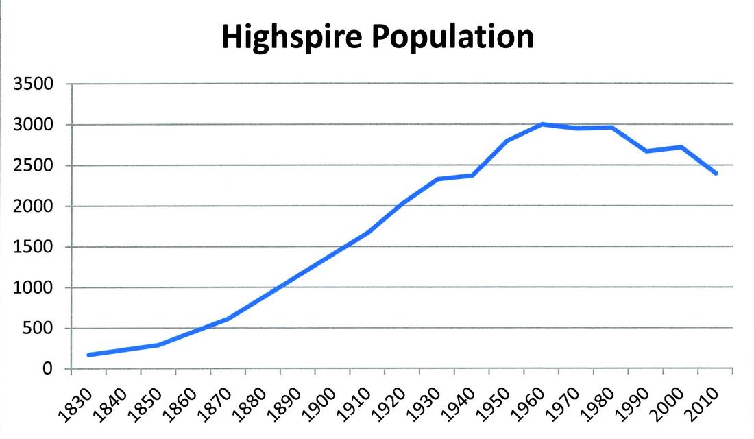
The geographic expansion of the village was reflected in the population growth. Before 1910 there were no separate census counts for Highspire because it was not a separate civil division of government. However, as an exception to the general rule the 1830, 1850 and 1870 censuses had a separate count for Highspire as a subset of Lower Swatara Township. As previously noted, the population of Highspire in 1850 was 291. The village grew rapidly, at a rate of about 40 percent per decade over the next two decades; the population in the 1870 Census was 612, including 11 foreign-born and 15 colored.
The first population count we have after incorporation was the 1910 Census. In that year the population was 1,669. So, from 1850 to 1910, Highspire grew at a rate of about 3 percent per year or 34 percent per decade for six decades. The population grew by 21 percent between 1910 and 1920, reaching 2,031 in the 1920 Census. The population grew by 15 percent in the 1920s reaching 2,327 in 1930, but in the decade of the Great Depression growth almost stopped, increasing by only 44 to 2,371 by 1940.
Some 150 years of population growth ended in the 1960s. The population in the 1960 Census was 2,999. It stayed around 3,000 for the next 20 years before declining to 2,720 in the 2000 Census and 2,399 in 2010. The population declined approximately 20 percent between 1980 and 2010.
Interpolation between missing 19th Century Data


